Italy: LiDAR Scanning for Solar Farms throughout the Country
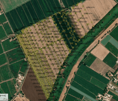
Drones Maritime, in collaboration with Sonnedix and subcontracted by Aeromedia, carried out advanced LiDAR scanning projects for the planning and development of solar parks in various locations in Italy, ranging from the north in Modena to the south in Sicily. These projects used Phoenix LiDAR systems, mounted on a DJI Matrice 350 RTK drone, connected to Topcon Italia's GNSS services, which ensured accurate georeferencing of the data obtained, and at each location, ground control points were taken using Leica RTK GPS equipment, a crucial measure to ensure maximum accuracy in terrain mapping.
Coordination with ENAC (Ente Nazionale per l'Aviazione Civile) was essential to ensure compliance with aviation safety regulations. This project reinforces Drones Maritime's role in implementing technological solutions for Italy's energy transition.
Innovation and challenges overcome
Energy Optimisation: This work was key to the planning of solar infrastructures that drive Italy's energy transition.
Sustainability: We contributed to the development of renewable energy sources, reducing dependence on fossil fuels.
Technological Advancement: Our drone technology approach has accelerated implementation and design processes.
Impact and benefits
Coordination with ENAC: We guarantee compliance with all air regulations with ENAC (Ente Nazionale per l'Aviazione Civile).
Varied Geographical Conditions: We adapt the technology to different terrains from densely populated areas to more rural areas and difficult to access terrain such as Sicily.
High Accuracy: The combined use of drones and RTK GPS ensured reliable data for accurate designs.
Location
Italy